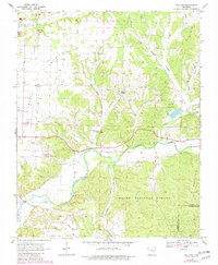
1970 Map of Gallatin
USGS Topo · Published 1982About this map
Ozark National Forest dominates the southern reaches of this landscape, where the Illinois River carves a winding path through the Ozark plateau. In the late 1960s and early 1970s, the rural character of western Benton County was defined by its scattered community centers and educational institutions, most notably the Ozark Academy and Camp Ozark near the northern boundary. The map captures a transition from the level terrain of Prairie in the northwest to the more complex topography of Lindsley and the Twin Mountains.
Find a feature on this map
38 named features on this map. Tap any name to fly to it.
Don’t see what you’re looking for? This feature index may not catch every label — zoom into the map to look around manually.
Map Details
Editions of this 1970 Gallatin Map
3 editions found
Other maps of this area

1899 · Fayetteville
USGS Topo · 1:125,000

1899 · Siloam Springs
USGS Topo · 1:125,000

1901 · Fayetteville
USGS Topo · 1:125,000

1903 · Siloam Springs
USGS Topo · 1:125,000

1904 · Siloam Springs
USGS Topo · 1:125,000

1904 · Fayetteville
USGS Topo · 1:125,000

1954 · Tulsa
USGS Topo · 1:250,000

1958 · Tulsa
USGS Topo · 1:250,000

1963 · Tulsa
USGS Topo · 1:250,000

1970 · Gallatin
USGS Topo · 1:24,000