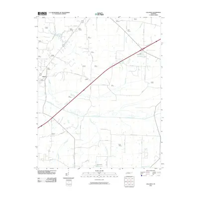
2010 Map of Gallaway
USGS Topo · Published 2010About this map
Gallaway serves as a central hub for this portion of Fayette County, where the landscape is defined by the winding course of the Loosahatchie River and its numerous tributaries. The map reveals an exceptionally dense concentration of family and community burial grounds, such as Hopewell Cemetery, Mount Sinai Cemetery, and the Hillard Nolley Cemetery, indicating deep-rooted genealogical history across the rural countryside. These sites are scattered along a network of local thoroughfares like Witherington Rd and Braden Rd, which link old homesteads to the river valley. The presence of water management features, including the W W Wilder Dam and Greshams Dam, illustrates how the Black Ankle Creek and Wilder Creek drainage basins have been modified to create recreational or agricultural reservoirs like Greshams Lake. This topographical record provides a clear view of the area's rural character and the enduring presence of historic community landmarks.
Find a feature on this map
56 named features on this map. Tap any name to fly to it.
Don’t see what you’re looking for? This feature index may not catch every label — zoom into the map to look around manually.
Map Details
Editions of this 2010 Gallaway Map
This is the sole edition of this map. No revisions or reprints were ever made.
Other maps of this area

1943 · Collierville
USGS Topo · 1:62,500

1949 · Moscow
USGS Topo · 1:62,500

1952 · Stanton
USGS Topo · 1:24,000

1952 · Lambert
USGS Topo · 1:24,000

1952 · Stanton
USGS Topo · 1:62,500

1953 · Collierville
USGS Topo · 1:50,000

1954 · Mason
USGS Topo · 1:62,500

1956 · Blytheville
USGS Topo · 1:250,000

1959 · Blytheville
USGS Topo · 1:250,000
1965 · Oakland
USGS Topo · 1:24,000