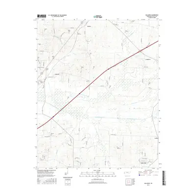
2016 Map of Gallaway
USGS Topo · Published 2016About this map
Gallaway and Braden anchor this West Tennessee landscape, where the agricultural traditions of Fayette County are etched into the map through an extensive network of family and community burial grounds. From Union Hill Cem and Hillard Nolley Cem in the south to Poplar Springs Cem and Flournoy Cem near the northern border, these sites offer a significant record for genealogical research. The terrain is defined by engineered water management, most notably the Loosahatchie River Canal and Little Cypress Cr Canal, which cut straight paths through the bottomlands to control seasonal flooding. This sophisticated drainage system, including the Laurel Cr Canal, transformed the wetlands surrounding Treadville Cr into viable farmland. In the eastern portion, Longtown sits near the headwaters of Wilder Cr, illustrating the small-scale settlement patterns that persisted alongside the massive 20th-century hydrological modifications.
Find a feature on this map
84 named features on this map. Tap any name to fly to it.
Don’t see what you’re looking for? This feature index may not catch every label — zoom into the map to look around manually.
Map Details
Editions of this 2016 Gallaway Map
This is the sole edition of this map. No revisions or reprints were ever made.
Other maps of this area

1943 · Collierville
USGS Topo · 1:62,500

1949 · Moscow
USGS Topo · 1:62,500

1952 · Stanton
USGS Topo · 1:24,000

1952 · Lambert
USGS Topo · 1:24,000

1952 · Stanton
USGS Topo · 1:62,500

1953 · Collierville
USGS Topo · 1:50,000

1954 · Mason
USGS Topo · 1:62,500

1956 · Blytheville
USGS Topo · 1:250,000

1959 · Blytheville
USGS Topo · 1:250,000
1965 · Oakland
USGS Topo · 1:24,000