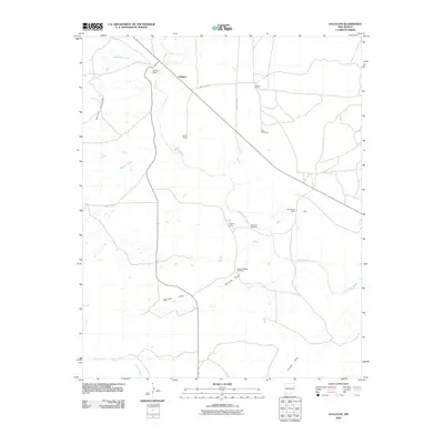
2010 Map of Gallegos
USGS Topo · Published 2010About this map
Gallegos and its surrounding ranchlands represent the cattle-country heritage of Harding County in the early twenty-first century. The landscape is defined by the winding course of Ute Creek, which serves as the primary drainage for the high plains of northeastern New Mexico. Settlement patterns here are characterized by large, sprawling holdings such as the Gallegos Ranch, Osborn Ranch, and Pomroy Ranch, reflecting the enduring pastoral economy of this semi-arid region. These family-named landmarks are connected by a network of rural routes including County Road H-1 and County Road H. Strategic water management for livestock is evident in the inclusion of essential infrastructure like the Twin Windmills and the Ute Creek Windmill. To the south, the topography transitions toward the Gravel Hills and the seasonal drainages of Ramirez Draw and Carros Creek.
Find a feature on this map
20 named features on this map. Tap any name to fly to it.
Don’t see what you’re looking for? This feature index may not catch every label — zoom into the map to look around manually.
Map Details
Editions of this 2010 Gallegos Map
This is the sole edition of this map. No revisions or reprints were ever made.
Other maps of this area

1930 · Tucumcari
USGS Topo · 1:125,000

1954 · Tucumcari
USGS Topo · 1:250,000

1958 · Tucumcari
USGS Topo · 1:250,000

1968 · Hampton Ranch
USGS Topo · 1:24,000

1968 · Montesito Creek
USGS Topo · 1:24,000
1968 · Medina Mesa
USGS Topo · 1:24,000

1969 · Gallegos
USGS Topo · 1:24,000

1969 · Gallegos NE
USGS Topo · 1:24,000

1969 · Salitre Canyon
USGS Topo · 1:24,000
1969 · Alamosa Canyon
USGS Topo · 1:24,000