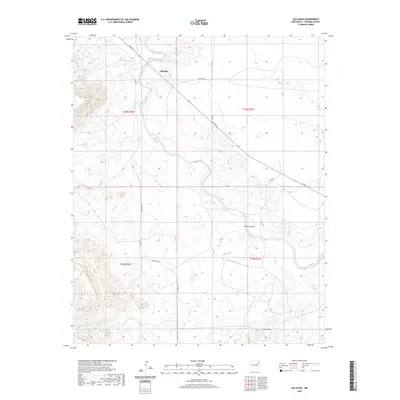
2020 Map of Gallegos
USGS Topo · Published 2020About this map
Gallegos sits at a crossroads in the northeastern New Mexico ranching country, where the arid high plains are carved by seasonal watercourses and low ridges. The settlement pattern here is defined by long, straight ranch roads like Red Rock Rd and Bryantine Rd that span the sections of the Public Land Survey System. The drainage network is central to the landscape, with the winding paths of Deposito Cr and Ramirez Draw providing the primary topography. In the southern portion of the quadrangle, the Gravel Hills rise above the surrounding terrain near Carros Cr, marking a distinct geological shift in this sparsely populated corner of Harding County.
Find a feature on this map
16 named features on this map. Tap any name to fly to it.
Don’t see what you’re looking for? This feature index may not catch every label — zoom into the map to look around manually.
Map Details
Editions of this 2020 Gallegos Map
This is the sole edition of this map. No revisions or reprints were ever made.
Other maps of this area

1930 · Tucumcari
USGS Topo · 1:125,000

1954 · Tucumcari
USGS Topo · 1:250,000

1958 · Tucumcari
USGS Topo · 1:250,000

1968 · Hampton Ranch
USGS Topo · 1:24,000

1968 · Montesito Creek
USGS Topo · 1:24,000
1968 · Medina Mesa
USGS Topo · 1:24,000

1969 · Gallegos
USGS Topo · 1:24,000

1969 · Gallegos NE
USGS Topo · 1:24,000

1969 · Salitre Canyon
USGS Topo · 1:24,000
1969 · Alamosa Canyon
USGS Topo · 1:24,000