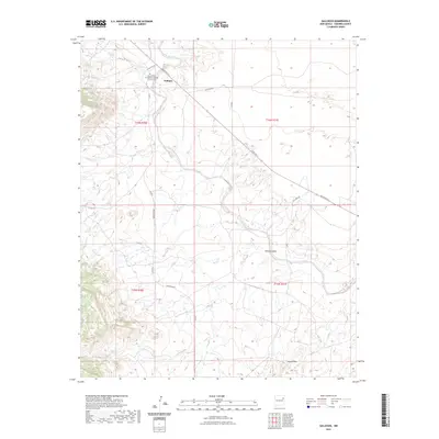
2023 Map of Gallegos
USGS Topo · Published 2023About this map
Gallegos serves as the primary focal point of this Harding County landscape, situated along the upper reaches of Deposito Creek. The small community is centered around the Immaculate Conception Catholic Church Cem, a site of significant local genealogical value for the area. The terrain is defined by the high plains of Northeast New Mexico, where the drainage systems of Ramirez Draw and Carros Creek carve subtle paths through the township. In the southern portion of the quadrangle, the Gravel Hills rise above the surrounding flats, while a network of rural routes like Bryantine Rd and Ute Camp Rd connect isolated ranching sites. The map illustrates a contemporary view of this enduring agricultural region, showing the persistent layout of roads and property boundaries within the Public Land Survey System.
Find a feature on this map
18 named features on this map. Tap any name to fly to it.
Don’t see what you’re looking for? This feature index may not catch every label — zoom into the map to look around manually.
Map Details
Editions of this 2023 Gallegos Map
This is the sole edition of this map. No revisions or reprints were ever made.
Other maps of this area

1930 · Tucumcari
USGS Topo · 1:125,000

1954 · Tucumcari
USGS Topo · 1:250,000

1958 · Tucumcari
USGS Topo · 1:250,000

1968 · Hampton Ranch
USGS Topo · 1:24,000

1968 · Montesito Creek
USGS Topo · 1:24,000
1968 · Medina Mesa
USGS Topo · 1:24,000

1969 · Gallegos
USGS Topo · 1:24,000

1969 · Gallegos NE
USGS Topo · 1:24,000

1969 · Salitre Canyon
USGS Topo · 1:24,000
1969 · Alamosa Canyon
USGS Topo · 1:24,000