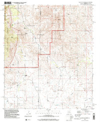
1996 Map of Galleta Flat West
USGS Topo · Published 2002About this map
Coronado National Forest and the eastern edge of the Saguaro National Park define this arid landscape along the Pima and Cochise County line. The terrain is marked by dramatic elevation changes rising toward North Star Peak in the Little Rincon Mountains, where numerous seasonal water sources like Bear Spring and Canoa Spring suggest the traditional importance of water management in the desert. Lowland areas reveal a pattern of ranching and remote settlement, notably at Mackenzie Ranch and Ashrama Ranch. The presence of the White Cross Cem near Agua Verde Creek provides a specific point of interest for genealogists, while several labeled Prospects in the eastern foothills point to historic mineral exploration. Drainage systems like Cumaro Canyon and Pacheco Wash carve through the foothills, illustrating the complex alluvial geography of the Galleta Flat Wash basin.
Find a feature on this map
25 named features on this map. Tap any name to fly to it.
Don’t see what you’re looking for? This feature index may not catch every label — zoom into the map to look around manually.
Map Details
Editions of this 1996 Galleta Flat West Map
This is the sole edition of this map. No revisions or reprints were ever made.
Other maps of this area

1904 · Patagonia
USGS Topo · 1:125,000

1904 · Tucson
USGS Topo · 1:125,000

1905 · Patagonia
USGS Topo · 1:125,000

1905 · Tucson
USGS Topo · 1:125,000

1915 · Benson
USGS Topo · 1:125,000

1926 · Whetstone
USGS Topo · 1:62,500

1943 · Benson
USGS Topo · 1:125,000

1945 · Happy Valley
USGS Topo · 1:62,500

1956 · Nogales
USGS Topo · 1:250,000

1956 · Tucson
USGS Topo · 1:250,000