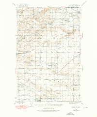
1938 Map of Gallup City
USGS Topo · Published 1976About this map
Gallup City sits at the heart of this late 1930s survey, a period when rural school districts and family ranching operations defined the social geography of the plains. The landscape is marked by a dense network of one-room schoolhouses, including the Spring Creek Sch, Brownell Sch, and Earhart Sch, reflecting a distributed population before the consolidation of mid-century education. Along the northern edge, the Marias River and its Dry Fork carve deep through the terrain, while the southern reaches are shaped by the Bynum Canal and Brady Canal irrigation systems.
Find a feature on this map
38 named features on this map. Tap any name to fly to it.
Don’t see what you’re looking for? This feature index may not catch every label — zoom into the map to look around manually.
Map Details
Editions of this 1938 Gallup City Map
2 editions found
Other maps of this area

1886 · Great Falls
USGS Topo · 1:250,000

1920 · Choteau
USGS Topo · 1:125,000

1920 · Dupuyer
USGS Topo · 1:125,000

1920 · Conrad
USGS Topo · 1:125,000

1934 · Lake Frances
USGS Topo · 1:48,000

1934 · Valier
USGS Topo · 1:62,500

1936 · Pendroy
USGS Topo · 1:48,000

1937 · Valier
USGS Topo · 1:62,500

1937 · Lake Frances
USGS Topo · 1:62,500

1938 · Gallup City
USGS Topo · 1:62,500