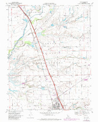
1968 Map of Galt
USGS Topo · Published 1980About this map
The Southern Pacific railroad corridor serves as the central spine for this late-1960s landscape, connecting the growing hub of Galt with northern settlements like Twin Cities and Mcconnel. This Central Valley region is defined by a dense network of watercourses, including the Cosumnes River and its many tributaries such as Badger Creek, Willow Creek, and Laguna Creek, which traverse the historic Spanish land grant boundaries of San Joan and Moquelumnes. The land use transition is evident in the cluster of institutions in Galt, such as High School and Fairsite School, while the surrounding rural landscape remains etched with family-named roads like Valensin Road and Marengo Road. Notable landmarks like the Hicksville cemetery and the rugged path of Deadman Gulch provide specific points of interest for those tracing local geography before modern suburban expansion.
Find a feature on this map
56 named features on this map. Tap any name to fly to it.
Don’t see what you’re looking for? This feature index may not catch every label — zoom into the map to look around manually.
Map Details
Editions of this 1968 Galt Map
3 editions found
Other maps of this area

1894 · Lodi
USGS Topo · 1:125,000

1908 · Lockeford
USGS Topo · 1:31,680

1909 · Elk Grove
USGS Topo · 1:31,680

1909 · Clay
USGS Topo · 1:31,680

1909 · Cosumnes
USGS Topo · 1:31,680

1909 · Florin
USGS Topo · 1:31,680

1910 · New Hope
USGS Topo · 1:31,680

1910 · Woodbridge
USGS Topo · 1:31,680

1910 · Bruceville
USGS Topo · 1:31,680

1910 · Galt
USGS Topo · 1:31,680