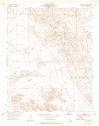
1954 Map of Galway Lake
USGS Topo · Published 1965About this map
Argos Mountain dominates the northern reaches of this mid-century survey, part of the larger Lava Bed Mountains that define the arid terrain of San Bernardino County. In the valley below, the ephemeral Galway Lake sits adjacent to a collection of desert activity, including a Well (Dry) and an Abandoned Landing Field that hint at past aviation or logistical efforts in this remote stretch of the Mojave.
Find a feature on this map
16 named features on this map. Tap any name to fly to it.
Don’t see what you’re looking for? This feature index may not catch every label — zoom into the map to look around manually.
Map Details
Editions of this 1954 Galway Lake Map
4 editions found
Other maps of this area

1901 · Southern California Sheet No. 1
USGS Topo · 1:250,000

1902 · San Gorgonio
USGS Topo · 1:125,000

1904 · Southern California Sheet No. 1
USGS Topo · 1:250,000

1953 · San Bernardino
USGS Topo · 1:250,000

1954 · Galway Lake
USGS Topo · 1:24,000

1954 · Hidalgo Mtn
USGS Topo · 1:24,000

1954 · Emerson Lake
USGS Topo · 1:24,000

1955 · Lavic SE
USGS Topo · 1:24,000

1955 · Silver Bell Mine
USGS Topo · 1:24,000

1955 · Sunshine Peak
USGS Topo · 1:24,000