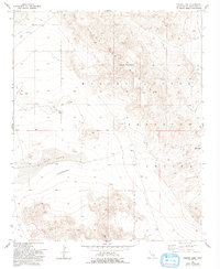
1954 Map of Galway Lake
USGS Topo · Published 1993About this map
Galway Lake sits at the heart of this high desert terrain, surrounded by the topographic relief of the Lava Bed Mountains. Established as part of the Marine Corps Training Center, the map reflects a landscape defined by military use and geological extremes. The arid surface is punctuated by mining activity, including the Maumee Mine and several scattered prospects that suggest the region's mineral history.
Find a feature on this map
11 named features on this map. Tap any name to fly to it.
Don’t see what you’re looking for? This feature index may not catch every label — zoom into the map to look around manually.
Map Details
Editions of this 1954 Galway Lake Map
4 editions found
Other maps of this area

1901 · Southern California Sheet No. 1
USGS Topo · 1:250,000

1902 · San Gorgonio
USGS Topo · 1:125,000

1904 · Southern California Sheet No. 1
USGS Topo · 1:250,000

1953 · San Bernardino
USGS Topo · 1:250,000

1954 · Galway Lake
USGS Topo · 1:24,000

1954 · Hidalgo Mtn
USGS Topo · 1:24,000

1954 · Emerson Lake
USGS Topo · 1:24,000

1955 · Lavic SE
USGS Topo · 1:24,000

1955 · Silver Bell Mine
USGS Topo · 1:24,000

1955 · Sunshine Peak
USGS Topo · 1:24,000