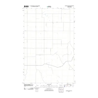
2011 Map of Gamache Creek
USGS Topo · Published 2011About this map
Gamache Creek and Short Creek define the drainage of this section of Williams County, where the landscape is etched with the precise grid of the Public Land Survey System. The map reveals a rural infrastructure dominated by a network of gravel and section-line roads such as 124th Ave NW and 57th St NW, facilitating transport across the expansive North Dakota prairie. Significant regional transit is marked by County Hwy-15 and County Hwy-42, which serve as the primary conduits for local agricultural commerce. Small seasonal water bodies and depressions dot the northern sections, illustrating the glacial topography characteristic of this region as it appeared in the early 21st century. This survey provides a clear view of land divisions and rural thoroughfares before significant modern development altered the area's footprint.
Find a feature on this map
17 named features on this map. Tap any name to fly to it.
Don’t see what you’re looking for? This feature index may not catch every label — zoom into the map to look around manually.
Map Details
Editions of this 2011 Gamache Creek Map
This is the sole edition of this map. No revisions or reprints were ever made.
Other maps of this area

1911 · Ray
USGS Topo · 1:125,000

1953 · Williston
USGS Topo · 1:250,000

1957 · Williston
USGS Topo · 1:250,000

1969 · Cussicks Spring
USGS Topo · 1:24,000

1978 · Lake Jessie
USGS Topo · 1:24,000

1978 · Ray
USGS Topo · 1:24,000

1978 · Epping
USGS Topo · 1:24,000
1978 · Banks
USGS Topo · 1:24,000

1978 · Spring Brook
USGS Topo · 1:24,000
1978 · Gamache Creek
USGS Topo · 1:24,000