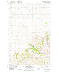
1978 Map of Gamache Creek
USGS Topo · Published 1979About this map
Gamache Creek and its surrounding drainage basins define the topography of this portion of Williams County, mapped during the late 1970s. The landscape is characterized by the organized township structure of Brooklyn and Twelve Mile, where section lines and rural tracks crisscross the high plains. A lone Townhall stands as a focal point for the local community amidst a network of seasonal watercourses including Spring Brook, Short Creek, and Long Cr. Evidence of local industry is sparse but present through a Gravel Pit located near the rugged breaks of the Truax terrain. The map reflects a period of established agricultural and civic organization in western North Dakota, before the large-scale industrial changes of later decades.
Find a feature on this map
9 named features on this map. Tap any name to fly to it.
Don’t see what you’re looking for? This feature index may not catch every label — zoom into the map to look around manually.
Map Details
Editions of this 1978 Gamache Creek Map
This is the sole edition of this map. No revisions or reprints were ever made.
Other maps of this area

1911 · Ray
USGS Topo · 1:125,000

1953 · Williston
USGS Topo · 1:250,000

1957 · Williston
USGS Topo · 1:250,000

1969 · Cussicks Spring
USGS Topo · 1:24,000

1978 · Lake Jessie
USGS Topo · 1:24,000

1978 · Ray
USGS Topo · 1:24,000

1978 · Epping
USGS Topo · 1:24,000
1978 · Banks
USGS Topo · 1:24,000

1978 · Spring Brook
USGS Topo · 1:24,000
1979 · Chris Creek
USGS Topo · 1:24,000