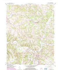
1954 Map of Gamaliel
USGS Topo · Published 1983About this map
Gamaliel serves as the primary hub in this mid-century survey of the Monroe Co landscape, situated just north of the Kentucky-Tennessee state line. The area is defined by the winding course of the Barren River and its numerous tributaries, including Line Creek and Peter Creek, which carve through the plateau. Small settlements and crossroads like Flippin, Gum Tree, and Emberton are connected by a network of rural roads, each anchored by local institutions like Harmony Ch and New Salem Ch.
Find a feature on this map
39 named features on this map. Tap any name to fly to it.
Don’t see what you’re looking for? This feature index may not catch every label — zoom into the map to look around manually.
Map Details
Editions of this 1954 Gamaliel Map
2 editions found
Other maps of this area

1929 · Tompkinsville
USGS Topo · 1:62,500

1931 · Red Boiling Springs
USGS Topo · 1:62,500

1953 · Tracy
USGS Topo · 1:24,000

1953 · Sulphur Lick
USGS Topo · 1:24,000

1953 · Freedom
USGS Topo · 1:24,000

1954 · Fountain Run
USGS Topo · 1:24,000

1954 · Gamaliel
USGS Topo · 1:24,000

1954 · Tompkinsville
USGS Topo · 1:24,000

1956 · Corbin
USGS Topo · 1:250,000

1958 · Corbin
USGS Topo · 1:250,000