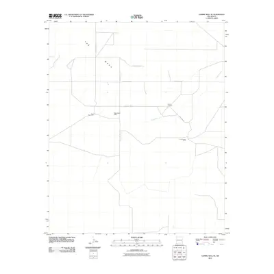
2010 Map of Gammil Well NE
USGS Topo · Published 2010About this map
The Mesa dominates the northern reaches of this high-plains landscape, where the flat topography is punctuated by Negrohead Butte. The area is defined by a sparse but organized network of rural roads, including S Roosevelt Road 2 and S Roosevelt Road AU, which serve isolated ranching operations. Significant local landmarks include the Price-Portales Ranch and Price West Camp, reflecting the prominent role of the Price family in the regional land use. The intermittent drainage of the Cañada del Tule meanders through the central terrain, providing a natural corridor across the otherwise grid-patterned roadway system. For those researching local family histories, the Benson Cemetery stands as a quiet coordinate on the landscape, located just off Price Ranch Rd.
Find a feature on this map
12 named features on this map. Tap any name to fly to it.
Don’t see what you’re looking for? This feature index may not catch every label — zoom into the map to look around manually.
Map Details
Editions of this 2010 Gammil Well NE Map
This is the sole edition of this map. No revisions or reprints were ever made.
Other maps of this area

1954 · Clovis
USGS Topo · 1:250,000

1957 · Melrose
USGS Topo · 1:62,500

1958 · Clovis
USGS Topo · 1:250,000

1973 · Lewiston Lake
USGS Topo · 1:24,000

1973 · Gammil Well SE
USGS Topo · 1:24,000

1973 · Tule Lake
USGS Topo · 1:24,000
1973 · Gammil Well
USGS Topo · 1:24,000

1973 · Gammil Well NE
USGS Topo · 1:24,000

1973 · Upton
USGS Topo · 1:24,000
1973 · Rippee Ranch
USGS Topo · 1:24,000