
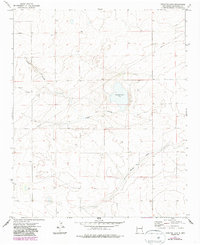
1973 Map of Lewiston Lake
USGS Topo · Published 1975About this map
Lewiston Lake (Salt) sits as a primary natural feature within this Roosevelt County landscape, its saline waters surrounded by the depression of Rabbit Hollow. The terrain is defined by its drainage patterns and subterranean resources, evidenced by numerous wells scattered across the township grid. While largely rural, the area is crossed by a notable Pipeline that traverses the northern and western sections, signaling the energy infrastructure of the early 1970s. In the southeastern portion, the land slopes toward Boone Draw, illustrating the subtle hydrological shifts in this high plains environment. The map details a period when resource extraction and livestock management were the primary drivers of land use, with a dense network of survey points and water sources anchoring the local geography.
Find a feature on this map
5 named features on this map. Tap any name to fly to it.
Don’t see what you’re looking for? This feature index may not catch every label — zoom into the map to look around manually.
Map Details
Editions of this 1973 Lewiston Lake Map
2 editions found
Other maps of this area

1954 · Clovis
USGS Topo · 1:250,000

1954 · Brownfield
USGS Topo · 1:250,000

1958 · Brownfield
USGS Topo · 1:250,000

1958 · Clovis
USGS Topo · 1:250,000

1962 · Brownfield
USGS Topo · 1:250,000

1973 · Floyd
USGS Topo · 1:24,000

1973 · Gammil Well SE
USGS Topo · 1:24,000

1973 · Gammil Well NE
USGS Topo · 1:24,000

1973 · Upton
USGS Topo · 1:24,000

1973 · Floyd SE
USGS Topo · 1:24,000