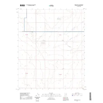
2023 Map of Gammil Well NE
USGS Topo · Published 2023About this map
Melrose Air Force Range occupies a significant portion of this high plains landscape, representing the intersection of modern military operations and historical ranching lands in eastern New Mexico. The terrain is defined by the prominent elevation of the Mesa and the distinct volcanic landmark of Negrohead Butte. This 2023 edition highlights how the grid of the Public Land Survey System, including Township 1 South, Range 30 East, continues to organize the sparse settlement pattern of Roosevelt County. Evidence of earlier family settlement remains at the Benson Cem, situated along the drainage of Cañada del Tule. The road network, including Mesa Rd and S Roosevelt Road 4, follows these sections, providing access to the remote ranchlands and the Price Ranch Rd area that characterize the region's contemporary economy.
Find a feature on this map
13 named features on this map. Tap any name to fly to it.
Don’t see what you’re looking for? This feature index may not catch every label — zoom into the map to look around manually.
Map Details
Editions of this 2023 Gammil Well NE Map
This is the sole edition of this map. No revisions or reprints were ever made.
Other maps of this area

1954 · Clovis
USGS Topo · 1:250,000

1957 · Melrose
USGS Topo · 1:62,500

1958 · Clovis
USGS Topo · 1:250,000

1973 · Lewiston Lake
USGS Topo · 1:24,000

1973 · Gammil Well SE
USGS Topo · 1:24,000

1973 · Tule Lake
USGS Topo · 1:24,000
1973 · Gammil Well
USGS Topo · 1:24,000

1973 · Gammil Well NE
USGS Topo · 1:24,000

1973 · Upton
USGS Topo · 1:24,000
1973 · Rippee Ranch
USGS Topo · 1:24,000