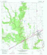
1963 Map of Ganado
USGS Topo · Published 1983About this map
The Navidad River and its winding tributaries, including Sutherland Creek and Brushy Creek, dominate this coastal prairie landscape in Jackson County. The town of Ganado serves as the regional hub, situated along the Southern Pacific railroad line. This era shows a landscape heavily influenced by the petroleum industry, with the Cordele Oil Field to the northwest and the Ganado West Oil Field south of town. Rural life is defined by a network of family-named roads like Matus Road, Thellmann Road, and Kuhlman Road. Cultural landmarks such as the Assumption Cemetery and Ganado Cem provide important reference points for local history. The presence of the Sandy Creek Oil Field and scattered wells underscores the economic drivers of the mid-20th century in this portion of Texas.
Find a feature on this map
27 named features on this map. Tap any name to fly to it.
Don’t see what you’re looking for? This feature index may not catch every label — zoom into the map to look around manually.
Map Details
Editions of this 1963 Ganado Map
2 editions found
Other maps of this area

1952 · Francitas NW
USGS Topo · 1:24,000

1952 · Manson
USGS Topo · 1:24,000

1952 · Edna
USGS Topo · 1:24,000

1953 · Beeville
USGS Topo · 1:250,000

1953 · Seguin
USGS Topo · 1:250,000

1956 · Beeville
USGS Topo · 1:250,000

1958 · Seguin
USGS Topo · 1:250,000

1960 · Beeville
USGS Topo · 1:250,000

1963 · Ganado
USGS Topo · 1:24,000

1963 · Mount Olive
USGS Topo · 1:24,000