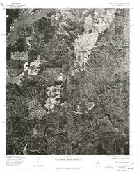
1975 Map of Gantts Quarry SW
USGS Topo · Published 1977About this map
Coosa River frontage and the upland ridges of central Alabama define this orthophotoquad, captured via aerial imagery in late 1975. The settlement of Talladega Springs occupies the northern reaches, while the smaller community of Marble Valley is situated further south among the wooded hills. Unlike a traditional line-drawn map, this imagery reveals the specific land-use patterns of the mid-1970s, showing the clearings for agriculture and timber alongside the winding riverbanks. The Coosa River appears here as a significant waterway, with its distinctive inlets and shoreline topography clearly visible before further modern development. This document serves as a grounded reference for researchers studying the physical landscape and rural settlement distribution in this portion of the state during the post-war era.
Find a feature on this map
3 named features on this map. Tap any name to fly to it.
Don’t see what you’re looking for? This feature index may not catch every label — zoom into the map to look around manually.
Map Details
Editions of this 1975 Gantts Quarry SW Map
This is the sole edition of this map. No revisions or reprints were ever made.
Other maps of this area

1890 · Bessemer
USGS Topo · 1:125,000

1890 · Talladega
USGS Topo · 1:125,000

1891 · Clanton
USGS Topo · 1:125,000

1892 · Talladega
USGS Topo · 1:125,000

1892 · Bessemer
USGS Topo · 1:125,000

1901 · Wetumpka
USGS Topo · 1:125,000

1903 · Wetumpka
USGS Topo · 1:125,000

1909 · Columbiana
USGS Topo · 1:62,500

1911 · Columbiana
USGS Topo · 1:62,500

1915 · Gantts Quarry
USGS Topo · 1:48,000
Featured Places
- Talladega Springs, AL
- Strickland Crossroads, AL
- Blue Springs, AL
- Marble Valley, AL
- Sulphur Spring, Talladega Springs