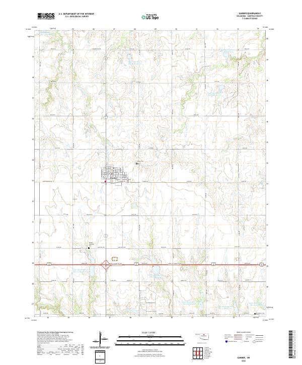
2022 Map of Garber
USGS Topo · Published 2022About this map
Garber serves as the central hub of this agricultural landscape in Garfield County, defined by a grid of rural roads and a complex network of managed water resources. The town's layout reflects its history, with streets like W Railroad St and E Choctaw radiating from the center. For genealogists and local historians, several burial grounds are documented across the plains, including Garber Cem, the Garber Lutheran Cem south of town, and the isolated Blackbear Cem in the southeastern corner. The surrounding terrain is heavily modified for water management, featuring numerous flood control structures such as Upper Red Rock Cr Site 41 Reservoir and Upper Black Bear Cr Site 30 Reservoir. These reservoirs sit alongside natural drainages like Black Bear Cr and Elkhorn Cr, illustrating the intensive land use of modern Oklahoma prairie country.
Find a feature on this map
62 named features on this map. Tap any name to fly to it.
Don’t see what you’re looking for? This feature index may not catch every label — zoom into the map to look around manually.
Map Details
Editions of this 2022 Garber Map
This is the sole edition of this map. No revisions or reprints were ever made.
Other maps of this area

1955 · Enid
USGS Topo · 1:250,000

1956 · Garber
USGS Topo · 1:62,500

1958 · Enid
USGS Topo · 1:250,000

1968 · Lamont SE
USGS Topo · 1:24,000

1968 · Billings
USGS Topo · 1:24,000

1968 · Hunter
USGS Topo · 1:24,000

1972 · Perry NW
USGS Topo · 1:24,000

1972 · Lucien
USGS Topo · 1:24,000
1979 · Perry NW
USGS Topo · 1:24,000
1982 · Garber
USGS Topo · 1:24,000