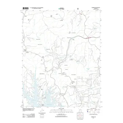
2012 Map of Garber
USGS Topo · Published 2012About this map
Silver Dollar City and the surrounding Ozark hills define this map, illustrating the intersection of tourism and local history. The rugged geography is marked by numerous high points, known locally as balds, including Garber Bald, Coxs Bald, and Dewey Bald. These elevations overlook the winding West Fork Roark Creek and the expansive waters of Table Rock Lake. Landmarks such as Marvel Cave and Inspiration Tower highlight the area's development as a destination, while the Rock Lane Lodge Marina and John the Diver Airport show the infrastructure supporting modern recreation.
Find a feature on this map
148 named features on this map. Tap any name to fly to it.
Don’t see what you’re looking for? This feature index may not catch every label — zoom into the map to look around manually.
Map Details
Editions of this 2012 Garber Map
This is the sole edition of this map. No revisions or reprints were ever made.
Other maps of this area

1907 · Forsyth
USGS Topo · 1:125,000

1945 · Harrison
USGS Topo · 1:250,000

1949 · Harrison
USGS Topo · 1:250,000

1950 · Garber
USGS Topo · 1:24,000

1954 · Harrison
USGS Topo · 1:250,000

1955 · Day
USGS Topo · 1:24,000

1956 · Lampe
USGS Topo · 1:24,000

1956 · Table Rock Dam
USGS Topo · 1:24,000

1956 · Garber
USGS Topo · 1:24,000
1956 · Spokane
USGS Topo · 1:24,000