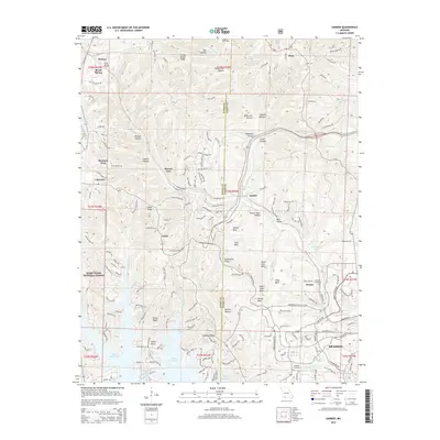
2015 Map of Garber
USGS Topo · Published 2015About this map
Marvel Cave and the limestone topography of the Ozarks define this landscape north of Branson. The terrain is marked by numerous distinctive peaks and hollows, including Garber Bald, Dewey Bald, and Mutton Hollow, reflecting the rugged character of the Mark Twain National Forest. Water is a central theme, from the established course of Roark Cr to the expansive southern shoreline of Table Rock Lake. Small settlements like Garber, Gretna, and Notch are interspersed with historical markers such as Evergreen Cemetery and Lewallen Cemetery. Transportation infrastructure highlights include the Reeds Spring Tunnel and the development around Branson West, showing how the region balanced its natural cave attractions with modern growth and reservoir management.
Find a feature on this map
169 named features on this map. Tap any name to fly to it.
Don’t see what you’re looking for? This feature index may not catch every label — zoom into the map to look around manually.
Map Details
Editions of this 2015 Garber Map
This is the sole edition of this map. No revisions or reprints were ever made.
Other maps of this area

1907 · Forsyth
USGS Topo · 1:125,000

1945 · Harrison
USGS Topo · 1:250,000

1949 · Harrison
USGS Topo · 1:250,000

1950 · Garber
USGS Topo · 1:24,000

1954 · Harrison
USGS Topo · 1:250,000

1955 · Day
USGS Topo · 1:24,000

1956 · Lampe
USGS Topo · 1:24,000

1956 · Table Rock Dam
USGS Topo · 1:24,000

1956 · Garber
USGS Topo · 1:24,000
1956 · Spokane
USGS Topo · 1:24,000