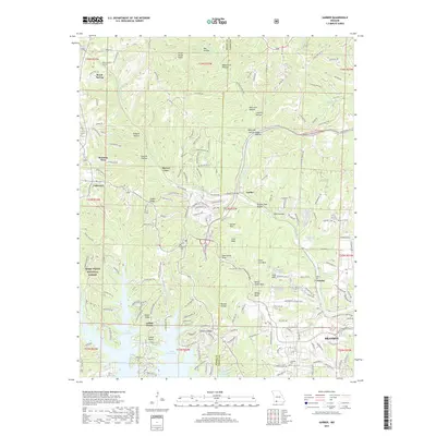
2017 Map of Garber
USGS Topo · Published 2017About this map
Table Rock Lake defines the southern reach of this landscape, its fingers reaching into Jacques Cr and Fall Cr near the burgeoning resort and residential developments of Indian Point and Branson West. The terrain is characterized by dramatic topographic relief, featuring numerous knobs locally identified as "balds," including Garber Bald, Coxs Bald, and Dewey Bald. These elevations overlook deep hollows such as Mutton Hollow and Possum Haw Hollow, reflecting the complex karst and river-carved geography of the White River hills. In the central portion of the map, Marvel Cave remains a prominent landmark near the winding Silver Dollar City Pkwy. Local history is preserved in the small rural settlements of Garber and Gretna, and within family-named burial grounds like Evergreen Cem and Lewallen Cem. The presence of the Mark Twain National Forest on the western edge highlights the region's managed timberlands amidst rapid tourism-driven growth.
Find a feature on this map
181 named features on this map. Tap any name to fly to it.
Don’t see what you’re looking for? This feature index may not catch every label — zoom into the map to look around manually.
Map Details
Editions of this 2017 Garber Map
This is the sole edition of this map. No revisions or reprints were ever made.
Other maps of this area

1907 · Forsyth
USGS Topo · 1:125,000

1945 · Harrison
USGS Topo · 1:250,000

1949 · Harrison
USGS Topo · 1:250,000

1950 · Garber
USGS Topo · 1:24,000

1954 · Harrison
USGS Topo · 1:250,000

1955 · Day
USGS Topo · 1:24,000

1956 · Lampe
USGS Topo · 1:24,000

1956 · Table Rock Dam
USGS Topo · 1:24,000

1956 · Garber
USGS Topo · 1:24,000
1956 · Spokane
USGS Topo · 1:24,000