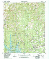
1989 Map of Garber
USGS Topo · Published 1989About this map
Silver Dollar City and the surrounding Ozark landscape dominate this late 1980s topographical study, capturing the intersection of early pioneer heritage and modern tourism. The map detail highlights the storied Marvel Cave and The Shepherd of the Hills Homestead, landmarks that helped define the regional identity. The cultural geography is further anchored by local institutions like Uncle Ikes Post Office and the Sycamore Log Church.
Find a feature on this map
43 named features on this map. Tap any name to fly to it.
Don’t see what you’re looking for? This feature index may not catch every label — zoom into the map to look around manually.
Map Details
Editions of this 1989 Garber Map
This is the sole edition of this map. No revisions or reprints were ever made.
Other maps of this area

1907 · Forsyth
USGS Topo · 1:125,000

1945 · Harrison
USGS Topo · 1:250,000

1949 · Harrison
USGS Topo · 1:250,000

1950 · Garber
USGS Topo · 1:24,000

1954 · Harrison
USGS Topo · 1:250,000

1955 · Day
USGS Topo · 1:24,000

1956 · Lampe
USGS Topo · 1:24,000

1956 · Table Rock Dam
USGS Topo · 1:24,000

1956 · Garber
USGS Topo · 1:24,000
1956 · Spokane
USGS Topo · 1:24,000