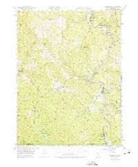
1949 Map of Garberville
USGS Topo · Published 1974About this map
The South Fork Eel River carves a winding path through the redwood country of southern Humboldt County, serving as the primary corridor for settlement and transit. In this mid-century period, the river valley is anchored by Garberville and Redway, with the legendary Humboldt Redwoods State Park protecting massive groves to the north. The map documents the importance of early conservation and tourism, highlighting numerous named stands such as Stephens Grove and Whittemore Grove. Away from the river, the landscape rises into steep territory along Elk Ridge and Mail Ridge, where more isolated communities like Briceland and Ettersburg persist. Educational centers like South Fork Union H S and the small Oakdale Sch indicate the rural infrastructure supporting the scattered timber and ranching families of the era.
Find a feature on this map
71 named features on this map. Tap any name to fly to it.
Don’t see what you’re looking for? This feature index may not catch every label — zoom into the map to look around manually.
Map Details
Editions of this 1949 Garberville Map
3 editions found

Other maps of this area

1919 · Glynn
USGS Topo · 1:62,500

1920 · Pt. Delagda
USGS Topo · 1:62,500

1920 · Cummings
USGS Topo · 1:62,500

1920 · Harris
USGS Topo · 1:62,500

1921 · Dyerville
USGS Topo · 1:62,500

1921 · Briceland
USGS Topo · 1:62,500

1949 · Eureka
USGS Topo · 1:250,000

1949 · Blocksburg
USGS Topo · 1:62,500

1949 · Alderpoint
USGS Topo · 1:62,500

1949 · Point Delgada
USGS Topo · 1:62,500