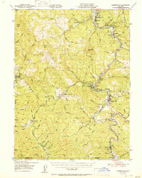
1951 Map of Garberville
USGS Topo · Published 1951About this map
The South Fork Eel River winds through a landscape of protected groves and logging-era settlements in this mid-century survey of southern Humboldt County. The map documents the early reach of U. S. Route 101 as it follows the river through Humboldt Redwoods State Park and Richardson Grove State Park. The distribution of local hubs like Garberville and Redway alongside remote outposts such as Ettersburg and Briceland reflects the region's complex terrain and timber-driven economy. Community life is anchored by landmarks such as the South Fork Union H S and the Garberville Airport, while the northern edge of Mendocino County appears near Cooks Valley. The detailed topography includes notable elevations like Gilham Butte and Elk Ridge, defining the watersheds of the Mattole River and various eel river tributaries.
Find a feature on this map
76 named features on this map. Tap any name to fly to it.
Don’t see what you’re looking for? This feature index may not catch every label — zoom into the map to look around manually.
Map Details
Editions of this 1951 Garberville Map
2 editions found

Other maps of this area

1919 · Glynn
USGS Topo · 1:62,500

1920 · Pt. Delagda
USGS Topo · 1:62,500

1920 · Cummings
USGS Topo · 1:62,500

1920 · Harris
USGS Topo · 1:62,500

1921 · Dyerville
USGS Topo · 1:62,500

1921 · Briceland
USGS Topo · 1:62,500

1949 · Eureka
USGS Topo · 1:250,000

1949 · Blocksburg
USGS Topo · 1:62,500

1949 · Alderpoint
USGS Topo · 1:62,500

1949 · Point Delgada
USGS Topo · 1:62,500