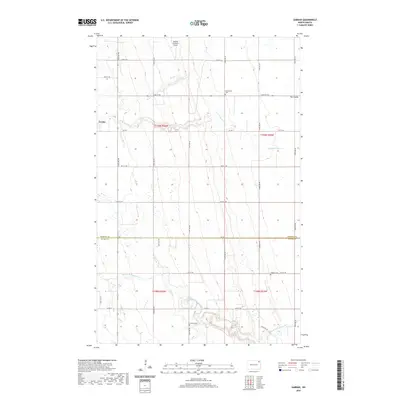
2020 Map of Gardar
USGS Topo · Published 2020About this map
Gardar sits at the intersection of a vast agricultural grid where the North Dakota prairie begins to dip toward the Pembina and Walsh county line. The landscape is defined by the winding paths of the N Br Park River and the Middle Br Park River, which break the geometric precision of the township range roads. This map documents a quiet rural pocket where local history is preserved in several burial grounds, including the Stokesville Cem, Hvideso Cem, and Lampton Cem. These sites, along with the Olafson Brothers Airport, serve as key landmarks for family researchers tracking the legacy of Icelandic and Scandinavian settlement in the region. The transition from the flat tableland of the east to the more varied terrain of The Coulee in the northeast corner reveals the subtle but important topography that influenced early road placement and property boundaries.
Find a feature on this map
29 named features on this map. Tap any name to fly to it.
Don’t see what you’re looking for? This feature index may not catch every label — zoom into the map to look around manually.
Map Details
Editions of this 2020 Gardar Map
This is the sole edition of this map. No revisions or reprints were ever made.
Other maps of this area

1944 · Crystal
USGS Topo · 1:62,500

1952 · Thief River Falls
USGS Topo · 1:250,000

1956 · Thief River Falls
USGS Topo · 1:250,000

1957 · Thief River Falls
USGS Topo · 1:250,000

1963 · Crystal
USGS Topo · 1:24,000

1963 · Edinburg
USGS Topo · 1:24,000

1963 · Gardar
USGS Topo · 1:24,000

1963 · Park River
USGS Topo · 1:24,000

1964 · Mountain
USGS Topo · 1:24,000
1964 · Hensel
USGS Topo · 1:24,000