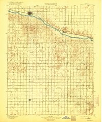
1896 Map of Garden City
USGS Topo · Published 1921About this map
Garden City and the Arkansas River corridor serve as the focal point for this late nineteenth-century survey of southwest Kansas. This territory, captured just after its initial settlement boom, shows the critical role of the Atchison Topeka and Santa Fe R. R. in dictating the path of growth. While the northern section follows the rail line through Sherlock and Pierceville, the southern half of the map reveals the grid-like organization of rural townships like Ivanhoe and Santa Fe. The landscape is characterized by its broad valleys and the distinct separation of the river lowlands from the surrounding upland prairies. For local historians, the map documents early county seat competition and the original locations of settlements like Lockport and Plymell before decades of twentieth-century agricultural consolidation altered the rural density.
Find a feature on this map
27 named features on this map. Tap any name to fly to it.
Don’t see what you’re looking for? This feature index may not catch every label — zoom into the map to look around manually.
Map Details
Editions of this 1896 Garden City Map
4 editions found
Other maps of this area

1891 · Larned
USGS Topo · 1:125,000

1892 · Meade
USGS Topo · 1:125,000

1892 · Dodge
USGS Topo · 1:125,000

1896 · Garden
USGS Topo · 1:125,000

1900 · Lakin
USGS Topo · 1:125,000

1944 · Tennis
USGS Topo · 1:62,500

1944 · Moscow
USGS Topo · 1:62,500

1945 · Moscow
USGS Topo · 1:62,500

1955 · Dodge City
USGS Topo · 1:250,000

1955 · Scott City
USGS Topo · 1:250,000