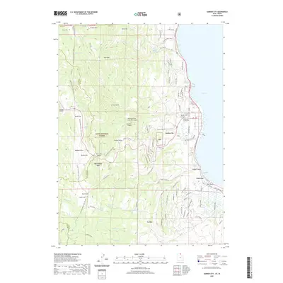
2020 Map of Garden City
USGS Topo · Published 2020About this map
Garden City and the settlement of Pickelville sit at the western edge of Bear Lake, where the shoreline meets the steep eastern slopes of the Cache National Forest. This modern survey illustrates a landscape defined by seasonal recreation and conservation, featuring numerous designated winter sports routes such as the Swan Flat Winter Sports and Amazon Hollow Winter Sports trails. High-elevation landmarks like Bridger Peak and Swan Peak overlook the basin, while the Old Limber Pine stands as a specific point of biological interest near Bear Lake Summit. The geography is intricately marked by drainages and hollows, including Hodges Canyon and Lone Pine Canyon, which feed into the lake. Recent development patterns are evident in the dense street grids of the lakeside communities, contrasting with the wilderness areas of the CNF and the quiet grounds of the Garden City Cem.
Find a feature on this map
90 named features on this map. Tap any name to fly to it.
Don’t see what you’re looking for? This feature index may not catch every label — zoom into the map to look around manually.
Map Details
Editions of this 2020 Garden City Map
This is the sole edition of this map. No revisions or reprints were ever made.
Other maps of this area

1909 · Montpelier
USGS Topo · 1:125,000

1911 · Montpelier
USGS Topo · 1:125,000

1912 · Randolph
USGS Topo · 1:125,000

1914 · Logan
USGS Topo · 1:125,000

1915 · Preston
USGS Topo · 1:96,000

1916 · Logan
USGS Topo · 1:125,000

1918 · Preston
USGS Topo · 1:125,000

1954 · Ogden
USGS Topo · 1:250,000

1955 · Preston
USGS Topo · 1:250,000

1958 · Ogden
USGS Topo · 1:250,000