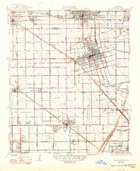
1935 Map of Garden Grove
USGS Topo · Published 1947About this map
Agricultural groves and developing town centers define the landscape of Orange County during the early 1930s. The region is heavily shaped by an extensive transportation network, including the Atchison Topeka and Santa Fe, Southern Pacific, and the Pacific Electric lines that connect the hubs of Anaheim and Garden Grove. Rural schoolhouses like Magnolia Sch No 2 and Loara Sch are scattered among the citrus lands, serving small communities such as Colonia Manzanillo and Brookhurst. Notable institutional landmarks include the County Farm and Hospital and the early Fullerton Landing Field, reflecting the era's mix of traditional farming and modernizing infrastructure. The seasonal course of the Santa Ana River and Santiago Creek border the eastern edge of this grid-iron layout, which was captured just before the postwar suburban expansion would fundamentally transform these orchards into a continuous metropolitan area.
Find a feature on this map
51 named features on this map. Tap any name to fly to it.
Don’t see what you’re looking for? This feature index may not catch every label — zoom into the map to look around manually.
Map Details
Editions of this 1935 Garden Grove Map
3 editions found
Other maps of this area

1896 · Santa Ana
USGS Topo · 1:62,500

1896 · Anaheim
USGS Topo · 1:62,500

1896 · Las Bolsas
USGS Topo · 1:62,500

1896 · Downey
USGS Topo · 1:62,500

1898 · Anaheim
USGS Topo · 1:62,500

1899 · Downey
USGS Topo · 1:62,500

1901 · Southern California Sheet No. 1
USGS Topo · 1:250,000

1901 · Santa Ana
USGS Topo · 1:62,500

1901 · Anaheim
USGS Topo · 1:62,500

1902 · Downey
USGS Topo · 1:62,500