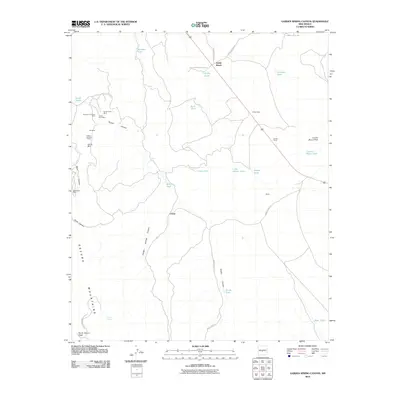
2010 Map of Garden Spring Canyon
USGS Topo · Published 2010About this map
White Sands Missile Range dominates this landscape in the northern reaches of the Oscura Mountains, where military restricted land meets traditional ranching and mineral exploration. The presence of the Adobe Ranch and the small settlement of Coane suggests the hardy agricultural roots of this arid region, while a cluster of mining activity to the west highlights its geologic value. A concentrated group of extraction sites including the Mountain Canyon Mine, Royal Flush Mine, and Mex Tex Mine are found along the slopes of Mine Canyon and Bruton Canyon. These names, alongside the mysterious Lorenzo Tunnel and the Optics installation, reveal a unique intersection of 20th-century defense operations and 19th-century prospecting. Transportation is limited to specialized military routes such as WSMR S Route 3505, weaving through a terrain defined by isolated water sources like Rock Tank and Griffin Tank.
Find a feature on this map
38 named features on this map. Tap any name to fly to it.
Don’t see what you’re looking for? This feature index may not catch every label — zoom into the map to look around manually.
Map Details
Editions of this 2010 Garden Spring Canyon Map
This is the sole edition of this map. No revisions or reprints were ever made.
Other maps of this area

1918 · Oscura Peak
USGS Topo · 1:125,000

1948 · Broken Back Crater
USGS Topo · 1:62,500

1948 · Bingham
USGS Topo · 1:62,500

1948 · Chihuahua Ranch
USGS Topo · 1:62,500

1948 · Mockingbird Gap
USGS Topo · 1:62,500

1954 · Tularosa
USGS Topo · 1:250,000

1958 · Tularosa
USGS Topo · 1:250,000
1981 · Cooper Canyon
USGS Topo · 1:24,000
1981 · Trinity Site
USGS Topo · 1:24,000
1981 · Wrye Peak NW
USGS Topo · 1:24,000