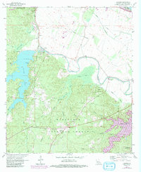
1971 Map of Gardner
USGS Topo · Published 1992About this map
Hot Wells and the surrounding pine-rich landscape of Kisatchie National Forest anchor this 1970s survey. The area is defined by its intricate hydrology, where Cocodrie Bayou and Jean de Jean Bayou meander through a series of small lakes like Crane Lake and Gourney Lake. This period captures the landscape just before significant modern development, with the Kincaid Reservoir and Lake Cotile providing established recreational hubs.
Find a feature on this map
56 named features on this map. Tap any name to fly to it.
Don’t see what you’re looking for? This feature index may not catch every label — zoom into the map to look around manually.
Map Details
Editions of this 1971 Gardner Map
3 editions found
Other maps of this area

1932 · Boyce NE
USGS Topo · 1:31,680

1932 · Boyce SW
USGS Topo · 1:31,680

1937 · Chopin NE
USGS Topo · 1:31,680

1937 · Chopin SE
USGS Topo · 1:31,680

1941 · Boyce
USGS Topo · 1:62,500

1943 · Leander
USGS Topo · 1:62,500

1944 · Chopin
USGS Topo · 1:62,500

1945 · Boyce SE
USGS Topo · 1:31,680

1948 · Chopin
USGS Topo · 1:62,500

1949 · Boyce NW
USGS Topo · 1:31,680