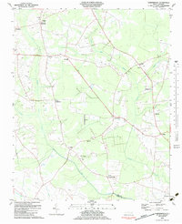
1983 Map of Gardnerville
USGS Topo · Published 1983About this map
The agricultural plains of eastern North Carolina define this 1983 survey, where small crossroads communities are linked by an extensive network of drainages and canals. Near the southern border, Gardnerville sits at the junction of local routes, while the St Johns Canal and Shiloh Canal indicate the long history of land management required for farming in the region. The landscape is dotted with numerous family cemeteries and small country churches, including Haddock Chapel and Spiritual Life Ch, which serve the surrounding rural population.
Find a feature on this map
30 named features on this map. Tap any name to fly to it.
Don’t see what you’re looking for? This feature index may not catch every label — zoom into the map to look around manually.
Map Details
Editions of this 1983 Gardnerville Map
This is the sole edition of this map. No revisions or reprints were ever made.
Other maps of this area

1902 · Ayden
USGS Topo · 1:62,500

1902 · Vanceboro
USGS Topo · 1:62,500

1903 · Winterville
USGS Topo · 1:62,500

1903 · Chocowinity
USGS Topo · 1:62,500

1904 · Ayden
USGS Topo · 1:62,500

1904 · Vanceboro
USGS Topo · 1:62,500

1905 · Chocowinity
USGS Topo · 1:62,500

1905 · Winterville
USGS Topo · 1:62,500

1905 · Vanceboro
USGS Topo · 1:62,500

1953 · Rocky Mount
USGS Topo · 1:250,000