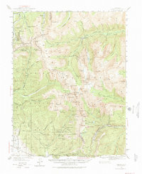
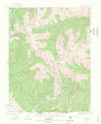
1940 Map of Garfield
USGS Topo · Published 1974About this map
St Elmo and the high mining camps of the Sawatch Range are documented here just before the mid-century, following surveys by Max J. Gleissner and M.C. McClellan. This landscape is defined by the extraction of silver and gold, with heavy concentration around the Brittle Silver Mine and Gold Cup Republic Mine. The infrastructure of the era is remarkably preserved on this sheet, showing the Denver and Rio Grande Western Railroad winding through the southern peaks near Monarch and Garfield. Higher in the mountains, the Alpine Tunnel Road and Cumberland Pass Road trace the difficult routes that once linked these isolated settlements. Water management for industrial and local use is evident at Boss Lake Reservoir and along the numerous forks of Chalk Creek, which served the smelters and mills at Iron City.
Find a feature on this map
84 named features on this map. Tap any name to fly to it.
Don’t see what you’re looking for? This feature index may not catch every label — zoom into the map to look around manually.
Map Details
Editions of this 1940 Garfield Map
6 editions found
Other maps of this area

1934 · Taylor Park
USGS Topo · 1:62,500

1937 · Taylor Park
USGS Topo · 1:62,500

1940 · Garfield
USGS Topo · 1:62,500

1941 · Pitkin
USGS Topo · 1:62,500

1945 · Pitkin
USGS Topo · 1:62,500

1945 · Garfield
USGS Topo · 1:62,500

1955 · Buena Vista
USGS Topo · 1:62,500

1955 · Mount Harvard
USGS Topo · 1:62,500

1956 · Poncha Springs
USGS Topo · 1:62,500

1956 · Montrose
USGS Topo · 1:250,000