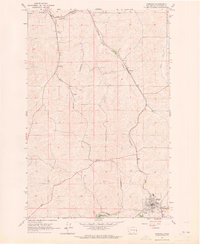
1964 Map of Garfield
USGS Topo · Published 1965About this map
The town of Garfield anchors the southeastern corner of this mid-1960s study, revealing a complex convergence of rail infrastructure and local topography. The rail network of the Palouse region is on full display, with the Union Pacific, Northern Pacific, and Great Northern lines threading through the landscape, serving small trackside settlements like Belmont, Robinson, and Sokulk. These small stops, along with landmarks such as Crabtree and Eden, trace a pattern of agricultural transport dependent on the creeks and valleys that define the county.
Find a feature on this map
23 named features on this map. Tap any name to fly to it.
Don’t see what you’re looking for? This feature index may not catch every label — zoom into the map to look around manually.
Map Details
Editions of this 1964 Garfield Map
This is the sole edition of this map. No revisions or reprints were ever made.
Other maps of this area

1903 · Oakesdale
USGS Topo · 1:125,000

1905 · Oakesdale
USGS Topo · 1:125,000

1910 · Pullman
USGS Topo · 1:125,000

1955 · Pullman
USGS Topo · 1:250,000

1955 · Spokane
USGS Topo · 1:250,000

1958 · Spokane
USGS Topo · 1:250,000

1958 · Pullman
USGS Topo · 1:250,000

1964 · Oakesdale
USGS Topo · 1:24,000

1964 · Elberton
USGS Topo · 1:24,000

1964 · Colfax North
USGS Topo · 1:24,000