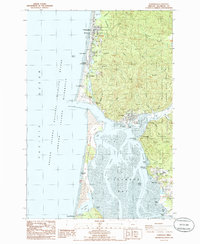
1985 Map of Garibaldi
USGS Topo · Published 1985About this map
Bayocean Peninsula serves as a narrow protective barrier between the Pacific Ocean and Tillamook Bay, most notably containing the Bayocean (Site). This location represents a significant historical point on the Oregon coast where a once-thriving resort community was lost to erosion, leaving only a geographic footprint by the mid-1980s. To the east, the timber-heavy slopes of the Tillamook State Forest descend toward the bay, where maritime and industrial life centers around Garibaldi and the Tillamook Bay Coast Guard Sta. The map documents a coastline defined by both natural preservation and managed resources, with the Oregon Islands National Wilderness Refuge protecting offshore rocks while the Miami River and Jacoby Creek feed into the tidal flats of the interior bay near Bay City and Hobsonville.
Find a feature on this map
57 named features on this map. Tap any name to fly to it.
Don’t see what you’re looking for? This feature index may not catch every label — zoom into the map to look around manually.
Map Details
Editions of this 1985 Garibaldi Map
2 editions found
Other maps of this area

1937 · Nehalem
USGS Topo · 1:62,500

1942 · Tillamook
USGS Topo · 1:62,500

1943 · Nehalem
USGS Topo · 1:62,500

1948 · Vancouver
USGS Topo · 1:250,000

1950 · Vancouver
USGS Topo · 1:250,000

1950 · Vancouver
USGS Topo · 1:250,000

1955 · Nehalem
USGS Topo · 1:62,500

1955 · Tillamook
USGS Topo · 1:62,500

1958 · Vancouver
USGS Topo · 1:250,000

1964 · Vancouver
USGS Topo · 1:250,000