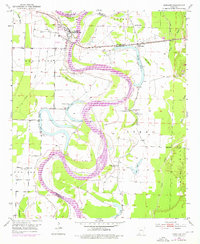
1952 Map of Garland
USGS Topo · Published 1976About this map
The winding Red River carves a complex course through the borderlands of Miller and Lafayette Counties, defining a landscape of active agriculture and oxbow lakes. Near the settlement of Garland, the Southwestern railroad crosses the river, supporting a local economy tied to the surrounding Oil Field and scattered Oil Wells. The map reveals a deeply rooted rural community, marked by numerous small churches including New Gum Point Ch and Old St Paul Ch. Educational and civic life are evidenced by the Wagoner Sch and the site of the Cedar Grove Sch (Abandoned), while the presence of the Bill Rogers Landing Strip suggests the early integration of aviation into this riverine environment. Elaborate levee systems trace the river's path, protecting the bottomlands around Spirit Lake and Cypress Lake from the frequent shifts of the waterway.
Find a feature on this map
37 named features on this map. Tap any name to fly to it.
Don’t see what you’re looking for? This feature index may not catch every label — zoom into the map to look around manually.
Map Details
Editions of this 1952 Garland Map
4 editions found
Other maps of this area

1952 · Garland
USGS Topo · 1:24,000

1952 · Fouke SE
USGS Topo · 1:24,000

1952 · Bradley NE
USGS Topo · 1:24,000

1952 · Old Town
USGS Topo · 1:24,000

1952 · Doddridge NE
USGS Topo · 1:24,000

1952 · Canfield
USGS Topo · 1:24,000

1952 · Lewisville
USGS Topo · 1:24,000

1952 · Fouke NE
USGS Topo · 1:24,000

1952 · Boyd Hill
USGS Topo · 1:24,000

1953 · El Dorado
USGS Topo · 1:250,000