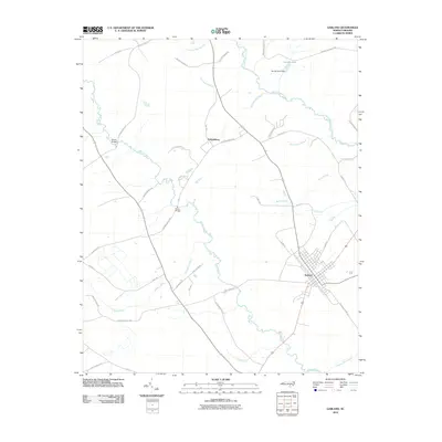
2010 Map of Garland
USGS Topo · Published 2010About this map
Garland stands as the primary hub in this coastal plain landscape, where a grid of local roads meets the riverine topography of Sampson County. The South River and Little Coharie Creek define the hydrologic character of the area, their wandering courses marked by historic crossing points like Melvin Bridge and Green Bridge. The map reveals a legacy of water-powered industry and drainage through features such as the Johnson Mill Race and the Derose Pond Dam near the northern boundary. Smaller tributaries, including Rattlesnake Branch and Turtle Branch, weave between family-named roads and rural homesteads. Significant swampy depressions like Bills Swamp remain prominent, illustrating the persistent challenge of the low-lying terrain. To the northwest, the smaller settlement of Parkersburg anchors a network of lanes including Old Tom Morris Rd and William Parker Ln, reflecting the deep-rooted family history of this North Carolina region.
Find a feature on this map
45 named features on this map. Tap any name to fly to it.
Don’t see what you’re looking for? This feature index may not catch every label — zoom into the map to look around manually.
Map Details
Editions of this 2010 Garland Map
This is the sole edition of this map. No revisions or reprints were ever made.
Other maps of this area

1953 · Florence
USGS Topo · 1:250,000

1954 · Florence
USGS Topo · 1:250,000

1954 · White Lake
USGS Topo · 1:62,500

1955 · Elizabethtown
USGS Topo · 1:62,500

1959 · Roseboro
USGS Topo · 1:62,500

1959 · Garland
USGS Topo · 1:62,500

1982 · Elizabethtown
USGS Topo · 1:100,000
1986 · Ingold
USGS Topo · 1:24,000
1986 · Garland
USGS Topo · 1:24,000
1986 · Clinton South
USGS Topo · 1:24,000