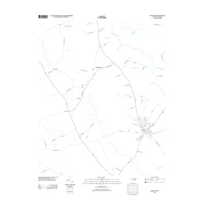
2013 Map of Garland
USGS Topo · Published 2013About this map
Garland serves as the primary hub in this portion of Sampson County, where a grid of streets intersects with local routes near the southern edge of Bills Swamp. The surrounding landscape is defined by a dense network of watercourses and drainages, including the Little Coharie Cr and the winding Cypress Cr. To the northwest, the small settlement of Parkersburg sits at a junction of rural roads, while the presence of Johnson Mill Race and Lockamy Mill Br point to a history of water-driven industry in the lowlands. The terrain is notably flat, supporting a mix of agricultural plots and wooded tracts accessed by family-named thoroughfares like Boykin Bridge Rd and Reeves Rd. Small-scale aviation is represented by the Twin Oak Airport in the northern reach of the survey, highlighting the area's transition between traditional rural life and modern utility.
Find a feature on this map
81 named features on this map. Tap any name to fly to it.
Don’t see what you’re looking for? This feature index may not catch every label — zoom into the map to look around manually.
Map Details
Editions of this 2013 Garland Map
This is the sole edition of this map. No revisions or reprints were ever made.
Other maps of this area

1953 · Florence
USGS Topo · 1:250,000

1954 · Florence
USGS Topo · 1:250,000

1954 · White Lake
USGS Topo · 1:62,500

1955 · Elizabethtown
USGS Topo · 1:62,500

1959 · Roseboro
USGS Topo · 1:62,500

1959 · Garland
USGS Topo · 1:62,500

1982 · Elizabethtown
USGS Topo · 1:100,000
1986 · Ingold
USGS Topo · 1:24,000
1986 · Garland
USGS Topo · 1:24,000
1986 · Clinton South
USGS Topo · 1:24,000