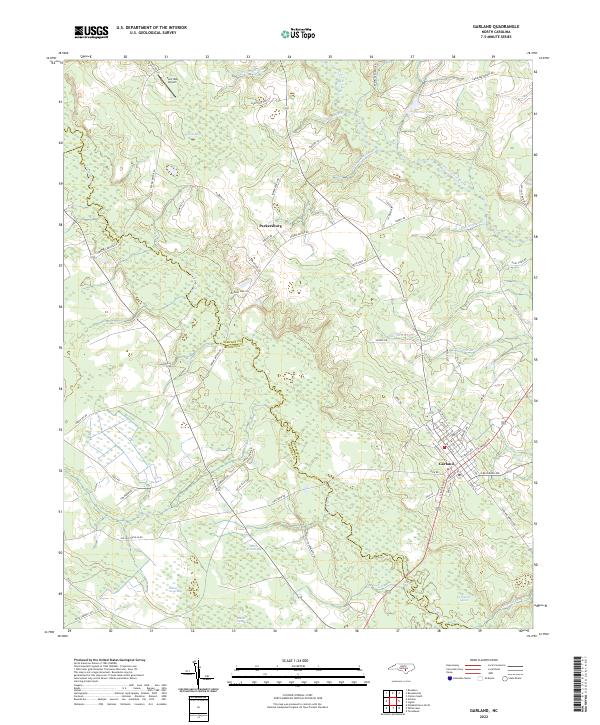
2022 Map of Garland
USGS Topo · Published 2022About this map
The town of Garland serves as a primary hub in this coastal plain landscape, where the South River and Little Coharie Creek define the local topography. This 2022 survey illustrates a region characterized by numerous elliptical depressions known as Carolina Bays, including Dismal Bay, Muddy Branch Bay, and Beaver Dam Bay. These distinctive features, along with Cromartie Marsh and Indian Camp Bay, suggest a complex hydrological network that has influenced local land use for generations.
Find a feature on this map
81 named features on this map. Tap any name to fly to it.
Don’t see what you’re looking for? This feature index may not catch every label — zoom into the map to look around manually.
Map Details
Editions of this 2022 Garland Map
This is the sole edition of this map. No revisions or reprints were ever made.
Other maps of this area

1953 · Florence
USGS Topo · 1:250,000

1954 · Florence
USGS Topo · 1:250,000

1954 · White Lake
USGS Topo · 1:62,500

1955 · Elizabethtown
USGS Topo · 1:62,500

1959 · Roseboro
USGS Topo · 1:62,500

1959 · Garland
USGS Topo · 1:62,500

1982 · Elizabethtown
USGS Topo · 1:100,000
1986 · Ingold
USGS Topo · 1:24,000
1986 · Garland
USGS Topo · 1:24,000
1986 · Clinton South
USGS Topo · 1:24,000