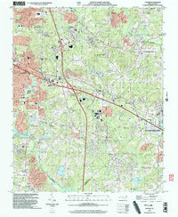
2002 Map of Garner
USGS Topo · Published 2004About this map
Lake Benson and the winding Swift Creek anchor the southern landscape of this early 21st-century study, where the growing suburbs of Garner meet the established agricultural research tracts of the North Carolina State University Central Crops Research Station. The map illustrates a transitional period of significant infrastructure development, highlighted by large highway interchanges such as Interchange 303 and Interchange 306, which bridge the gap between rural homesteads and expanding residential neighborhoods.
Find a feature on this map
45 named features on this map. Tap any name to fly to it.
Don’t see what you’re looking for? This feature index may not catch every label — zoom into the map to look around manually.
Map Details
Editions of this 2002 Garner Map
This is the sole edition of this map. No revisions or reprints were ever made.
Other maps of this area

1943 · Raleigh
USGS Topo · 1:62,500

1951 · Raleigh
USGS Topo · 1:62,500

1953 · Raleigh
USGS Topo · 1:250,000

1954 · Raleigh
USGS Topo · 1:250,000

1964 · Lake Wheeler
USGS Topo · 1:24,000

1964 · Garner
USGS Topo · 1:24,000

1964 · Selma
USGS Topo · 1:62,500

1964 · Angier
USGS Topo · 1:24,000

1964 · Clayton
USGS Topo · 1:24,000

1964 · Edmondson
USGS Topo · 1:24,000