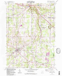
1994 Map of Garrettsville
USGS Topo · Published 1997About this map
The village of Garrettsville serves as a focal point in this portion of Northeast Ohio, where the headwaters of the Mahoning River and Eagle Creek converge. The landscape is defined by its unique glacial geology, most notably the towering sandstone formations at Nelson-Kennedy Ledges State Park, including Nelson Ledge and Kennedy Ledge. These features provide a sharp contrast to the surrounding agricultural and residential layout of Hiram, Nelson, and Freedom townships.
Find a feature on this map
74 named features on this map. Tap any name to fly to it.
Don’t see what you’re looking for? This feature index may not catch every label — zoom into the map to look around manually.
Map Details
Editions of this 1994 Garrettsville Map
This is the sole edition of this map. No revisions or reprints were ever made.
Other maps of this area

1905 · Bristolville
USGS Topo · 1:62,500

1905 · Garrettsville
USGS Topo · 1:62,500

1906 · Ravenna
USGS Topo · 1:62,500

1907 · Bristolville
USGS Topo · 1:62,500

1907 · Garrettsville
USGS Topo · 1:62,500

1908 · Warren
USGS Topo · 1:62,500

1908 · Ravenna
USGS Topo · 1:62,500

1950 · Cleveland
USGS Topo · 1:250,000

1952 · West Farmington
USGS Topo · 1:24,000

1952 · Southington
USGS Topo · 1:24,000