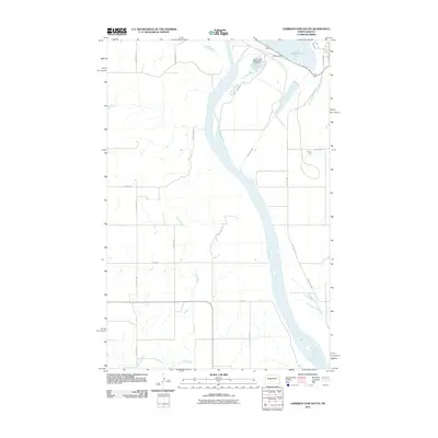
2011 Map of Garrison Dam South
USGS Topo · Published 2011About this map
Garrison Dam stands as a massive structural landmark in this Missouri River landscape, regulating the waters of Lake Sakakawea at the northern edge of the map. The downstream area is characterized by the complex water management of the Garrison Dam National Fish Hatchery, situated just below the dam. Moving south, the Missouri River meanders through a landscape defined by a grid of rural roads and natural tributaries. Agricultural and local transport patterns are visible through arterial routes like County Hwy-14 and County Hwy-18, while smaller waterways such as Elm Creek and Raymond Creek drain the western plains. This map illustrates the intersection of major federal hydraulic engineering and the traditional rural North Dakota grid system in the early 21st century.
Find a feature on this map
23 named features on this map. Tap any name to fly to it.
Don’t see what you’re looking for? This feature index may not catch every label — zoom into the map to look around manually.
Map Details
Editions of this 2011 Garrison Dam South Map
This is the sole edition of this map. No revisions or reprints were ever made.
Other maps of this area
1922 · Garrison
USGS Topo · 1:62,500
1948 · Stanton
USGS Topo · 1:62,500
1949 · Stanton
USGS Topo · 1:62,500
1954 · McClusky
USGS Topo · 1:250,000
1958 · McClusky
USGS Topo · 1:250,000
1967 · Stanton SE
USGS Topo · 1:24,000
1967 · Emmet SE
USGS Topo · 1:24,000
1968 · Stanton
USGS Topo · 1:24,000
1968 · Hazen East
USGS Topo · 1:24,000
1969 · Hazen NE
USGS Topo · 1:24,000