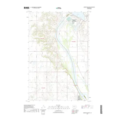
2018 Map of Garrison Dam South
USGS Topo · Published 2018About this map
Riverdale and the massive infrastructure of the Garrison Dam anchor this landscape along the Missouri River in the late 2010s. The map illustrates a complex intersection of federal conservation and historical preservation, featuring the Garrison Dam National Fish Hatchery alongside the Garrison Dam Recreational Airpark. Downstream, the border between Mercer and McLean counties follows the river's path toward the Knife River Indian Villages National Historic Site. To the west, the terrain rises into coulees and draws drained by Elm Cr and Raymond Cr. Local genealogy and land use are marked by sites like Saint Pauls Cem, situated among a network of rural routes such as Co Rd 28 and Main St. The survey captures the contrast between the engineered shoreline of Lake Sakakawea and the traditional section-line agriculture of the surrounding North Dakota plains.
Find a feature on this map
35 named features on this map. Tap any name to fly to it.
Don’t see what you’re looking for? This feature index may not catch every label — zoom into the map to look around manually.
Map Details
Editions of this 2018 Garrison Dam South Map
This is the sole edition of this map. No revisions or reprints were ever made.
Other maps of this area

1922 · Garrison
USGS Topo · 1:62,500

1948 · Stanton
USGS Topo · 1:62,500

1949 · Stanton
USGS Topo · 1:62,500

1954 · McClusky
USGS Topo · 1:250,000

1958 · McClusky
USGS Topo · 1:250,000

1967 · Stanton SE
USGS Topo · 1:24,000

1967 · Emmet SE
USGS Topo · 1:24,000

1968 · Stanton
USGS Topo · 1:24,000

1968 · Hazen East
USGS Topo · 1:24,000

1969 · Hazen NE
USGS Topo · 1:24,000