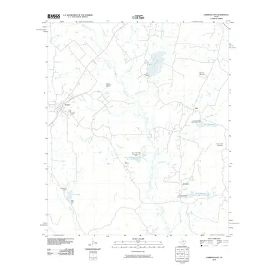
2010 Map of Garrison East
USGS Topo · Published 2010About this map
The town of Garrison serves as a focal point for this East Texas landscape, where the dendritic drainage patterns of the Attoyac River and its numerous tributaries like Lick Creek and Hardage Creek define the geography. This 2010 survey illustrates a region shaped by modern conservation efforts, evidenced by several water management projects including the Soil Conservation Service Site 18a Reservoir and Soil Conservation Service Site 12 Reservoir. Small rural settlements such as Silas and Stockman are scattered through the wooded terrain, providing valuable touchstones for local genealogists. The topography is marked by modest elevations like Bennett Mountain and Hollow Rock Mountain, while the presence of Greenwood Cemetery and Moss Cemetery alongside small airstrips like R D Williams Airport reflects a mix of deep-rooted heritage and modern utility in Nacogdoches County.
Find a feature on this map
30 named features on this map. Tap any name to fly to it.
Don’t see what you’re looking for? This feature index may not catch every label — zoom into the map to look around manually.
Map Details
Editions of this 2010 Garrison East Map
This is the sole edition of this map. No revisions or reprints were ever made.
Other maps of this area

1952 · Nacogdoches
USGS Topo · 1:62,500

1953 · Palestine
USGS Topo · 1:250,000

1957 · Palestine
USGS Topo · 1:250,000

1958 · Martinsville
USGS Topo · 1:62,500

1958 · Timpson
USGS Topo · 1:62,500

1960 · Mount Enterprise
USGS Topo · 1:62,500
1983 · Appleby
USGS Topo · 1:24,000

1984 · Palestine
USGS Topo · 1:250,000
1984 · Garrison East
USGS Topo · 1:24,000
1984 · Timpson
USGS Topo · 1:24,000