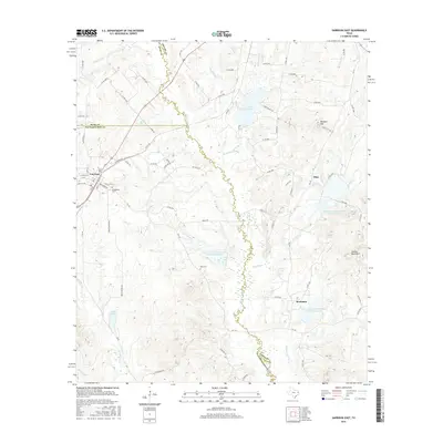
2016 Map of Garrison East
USGS Topo · Published 2016About this map
The Attoyac River carves a winding course through this 2016 survey of East Texas, serving as a natural boundary between Nacogdoches and Shelby counties. The town of Garrison serves as the primary hub in the northwest, where family history researchers will find the Greenwood Cem nearby. Further east across the river, the small settlements of Silas and Stockman are surrounded by a landscape increasingly defined by water management, featuring numerous catchments like the Soil Conservation Service Site 12 Reservoir. Topographical landmarks such as Bennett Mtn and Hollow Rock Mtn rise above the drainage basins of Bear Bayou and Stockman Cr, illustrating the undulating terrain of this piney woods region. The map also captures several smaller water bodies, including Lake Timpson and Lake Tinkle, which dot the rural countryside.
Find a feature on this map
83 named features on this map. Tap any name to fly to it.
Don’t see what you’re looking for? This feature index may not catch every label — zoom into the map to look around manually.
Map Details
Editions of this 2016 Garrison East Map
This is the sole edition of this map. No revisions or reprints were ever made.
Other maps of this area

1952 · Nacogdoches
USGS Topo · 1:62,500

1953 · Palestine
USGS Topo · 1:250,000

1957 · Palestine
USGS Topo · 1:250,000

1958 · Martinsville
USGS Topo · 1:62,500

1958 · Timpson
USGS Topo · 1:62,500

1960 · Mount Enterprise
USGS Topo · 1:62,500
1983 · Appleby
USGS Topo · 1:24,000

1984 · Palestine
USGS Topo · 1:250,000
1984 · Garrison East
USGS Topo · 1:24,000
1984 · Timpson
USGS Topo · 1:24,000