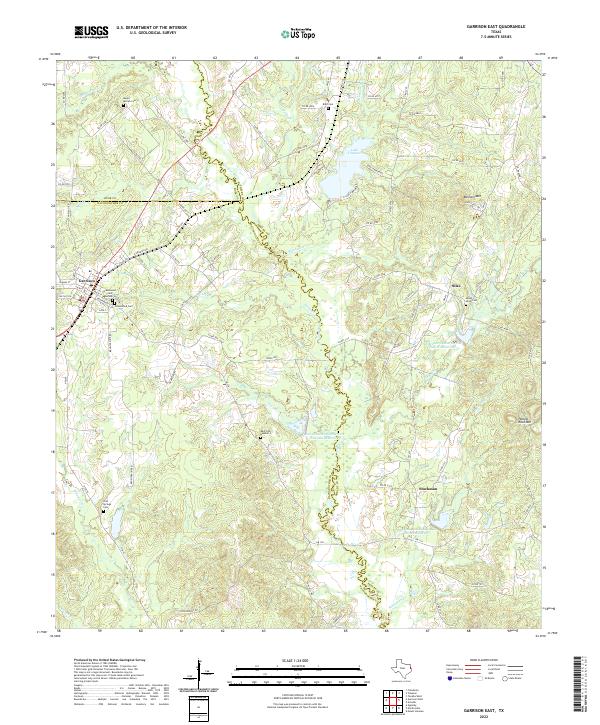
2022 Map of Garrison East
USGS Topo · Published 2022About this map
The Attoyac River and Blackwater Cr define the rural landscape of East Texas on the border of Nacogdoches and Shelby counties. This area is characterized by a network of small settlements and family burial grounds, including the Greenwood Cem in Garrison and the remote Mast Cem Number 2 located near the Soil Conservation Service Site 18a Reservoir. The topography transitions from the river lowlands to prominent rises such as Bennett Mtn and Hollow Rock Mtn. Modern water management is evident through several Soil Conservation Service reservoirs, while historical continuity is preserved in communities like Silas and Stockman. The map provides a detailed view of the regional road system, from state routes like FM 138 to local thoroughfares such as Brush Prairie Rd, connecting these scattered agricultural and residential outposts.
Find a feature on this map
92 named features on this map. Tap any name to fly to it.
Don’t see what you’re looking for? This feature index may not catch every label — zoom into the map to look around manually.
Map Details
Editions of this 2022 Garrison East Map
This is the sole edition of this map. No revisions or reprints were ever made.
Other maps of this area

1952 · Nacogdoches
USGS Topo · 1:62,500

1953 · Palestine
USGS Topo · 1:250,000

1957 · Palestine
USGS Topo · 1:250,000

1958 · Martinsville
USGS Topo · 1:62,500

1958 · Timpson
USGS Topo · 1:62,500

1960 · Mount Enterprise
USGS Topo · 1:62,500
1983 · Appleby
USGS Topo · 1:24,000

1984 · Palestine
USGS Topo · 1:250,000
1984 · Garrison East
USGS Topo · 1:24,000
1984 · Timpson
USGS Topo · 1:24,000