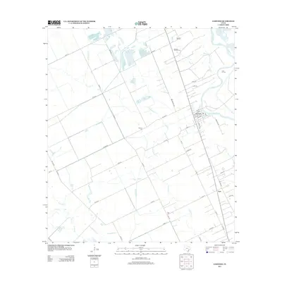
2013 Map of Garwood
USGS Topo · Published 2013About this map
The Colorado River winds through the agricultural landscape of Colorado County, anchoring the settlements of Garwood and Nada. This 2013 survey illustrates a region defined by its water management and petroleum extraction, with numerous canals and drainage creeks like W Mustang Cr and Bucksnag Cr supporting the surrounding fields. The energy economy is evident through the Englehart Oil Field to the north and the Frnka Oil Field to the east, indicating the continued industrial importance of the Texas Gulf Coast prairies. Local heritage is preserved at several burial sites, including the Garwood Methodist Cem and the Nada Cem, which serve as vital markers for genealogical research in these small rural communities. The map also detail the complex local road network, from established farm-to-market routes like FM 1693 RD to family-named paths such as Old Boenisch RD and Cranek RD.
Find a feature on this map
45 named features on this map. Tap any name to fly to it.
Don’t see what you’re looking for? This feature index may not catch every label — zoom into the map to look around manually.
Map Details
Editions of this 2013 Garwood Map
This is the sole edition of this map. No revisions or reprints were ever made.
Other maps of this area

1953 · Seguin
USGS Topo · 1:250,000

1956 · Glidden
USGS Topo · 1:62,500

1957 · Eagle Lake
USGS Topo · 1:62,500

1957 · Altair
USGS Topo · 1:24,000

1958 · Seguin
USGS Topo · 1:250,000

1959 · Garwood
USGS Topo · 1:24,000

1959 · Bonus
USGS Topo · 1:24,000

1960 · New Taiton
USGS Topo · 1:24,000
1963 · Eagle Lake
USGS Topo · 1:24,000

1965 · Rock Island
USGS Topo · 1:24,000