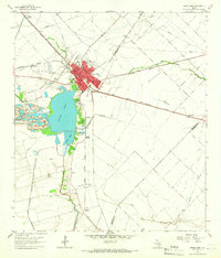
1963 Map of Eagle Lake
USGS Topo · Published 1965About this map
Eagle Lake serves as the focal point of this coastal prairie landscape, its waters flanked by the Silver Creek Fish Hatchery and a series of industrial Gravel Pits. In the early 1960s, the town of Eagle Lake was a hub of transport and industry, defined by the intersection of the Southern Pacific and the Gulf Colorado and Santa Fe railroads. The settlement pattern reveals distinct community hubs, with Greater Rising Star Ch and White Cloud Ch situated on the western outskirts, while the southern reaches towards Matthews are marked by the Mount Zion Ch and its accompanying Mount Zion Cem. This era shows a land heavily utilized for its resources, from the intensive Strip Mine operations west of the lake to the spreading infrastructure of the Lissie Oil Field and West Bernard Oil Field to the east and south.
Find a feature on this map
40 named features on this map. Tap any name to fly to it.
Don’t see what you’re looking for? This feature index may not catch every label — zoom into the map to look around manually.
Map Details
Editions of this 1963 Eagle Lake Map
2 editions found
Other maps of this area

1952 · Egypt
USGS Topo · 1:24,000

1953 · Seguin
USGS Topo · 1:250,000

1956 · Wallis
USGS Topo · 1:62,500

1957 · Eagle Lake
USGS Topo · 1:62,500

1957 · Altair
USGS Topo · 1:24,000

1958 · Seguin
USGS Topo · 1:250,000

1958 · Alleyton
USGS Topo · 1:24,000

1959 · Garwood
USGS Topo · 1:24,000

1959 · Bonus
USGS Topo · 1:24,000

1960 · Lissie
USGS Topo · 1:24,000