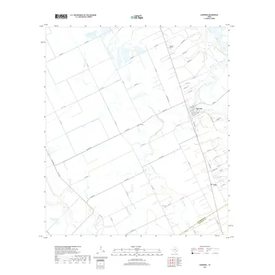
2019 Map of Garwood
USGS Topo · Published 2019About this map
Garwood and Nada serve as the primary hubs of this agricultural pocket in Colorado County, where the landscape is intricately defined by a network of drainage and irrigation. The Colorado River snakes along the eastern edge of the quadrangle, flanked by numerous tributaries such as W Mustang Cr and Marys Br. This area shows a clear transition between organized river-bottom lands and the structured grid of rural farm roads, including FM 1693 RD and FM 333 RD. Genealogists will find particular value in the documentation of several local burial sites, most notably the Garwood Methodist Cem, the Garwood Cem, and the Nada Cem further south. The presence of Engstrom Lake Number 2 and various creeks like Bucksnag Cr and Pinoak Cr highlights the water-dependent nature of this Texas coastal prairie region, where land use remains closely tied to the natural hydrology and the county boundary with Wharton County.
Find a feature on this map
62 named features on this map. Tap any name to fly to it.
Don’t see what you’re looking for? This feature index may not catch every label — zoom into the map to look around manually.
Map Details
Editions of this 2019 Garwood Map
This is the sole edition of this map. No revisions or reprints were ever made.
Other maps of this area

1953 · Seguin
USGS Topo · 1:250,000

1956 · Glidden
USGS Topo · 1:62,500

1957 · Eagle Lake
USGS Topo · 1:62,500

1957 · Altair
USGS Topo · 1:24,000

1958 · Seguin
USGS Topo · 1:250,000

1959 · Garwood
USGS Topo · 1:24,000

1959 · Bonus
USGS Topo · 1:24,000

1960 · New Taiton
USGS Topo · 1:24,000
1963 · Eagle Lake
USGS Topo · 1:24,000

1965 · Rock Island
USGS Topo · 1:24,000